


Helicopter Preflight
(Reviewed on 6th February 2021)
Preparing For Flight
We all go out to our helicopter and complete our daily preflight inspection before flying. But what exactly does the preflight consist of? Is it just a matter of checking the mechanics of the helicopter? Of course this is a very important check but there are many more things to check and consider.
- Licence expiry date
- Medical expiry date
- LPC renewal date
- Aircraft documentation
- Location of helicopter
- Fuel
- Mass and balance
- Meteorological reports
- Fitness for flight
- Passenger brief
- Dangerous goods
- Airport layout and procedures
- Planning, ATC and route
- Performance
- Equipment
- Prior permission to land at destination
Some of the above items may seem obvious to you but I bet that you do not check all of them. I may even have missed a few. But let’s look at these in a little more detail.
Licence expiry date
Were you aware that your JAR licence has an expiry date? Take it out and have a look at it. It is not obvious but normally, on the second or third page, there will be an expiry date. Put this date in your calendar and set an alarm to remind you to renew it – no one else is going to do this for you. There will be no letters to remind you.
Your licence is only valid for five years. This is separate from your type rating.
Obviously you must not fly if it has expired.
Medical expiry date
Check the expiry date of your medical certificate. Do you have to wear corrective lenses? Do you have a second pair as stated on your medical certificate?
Again, program the expiry date into your calender with an alarm to remind you to renew it before it expires.
LPC renewal date
Check the date when your LPC is due for renewal for the type of aircraft you are flying. Use the calender again.
Aircraft documentation
Make sure the aircraft is airworthy. Check the following documents:
- Certificate of Registration (CoR) (no expiry date).
- Certificate of Airworthiness (CoA). This is being replaced by an Airworthiness Review Certificate
- Certificate of Release to Service (CRS). Check that the helicopter has not exceeded the hours and dates for required maintenance.
- Airworthiness Review Certificate (ARC). This is an ongoing, continuous airworthiness program certificate. Check the expiry date.
- Noise Certificate (no expiry date)
- Aircraft Station License (for radio equipment) (no expiry date).
- Third party liability insurance (check the expiry date).
- Mass and balance schedule
- Rules of interception. This is required by law in Ireland or when crossing an international FIR.
- Technical log for the aircraft. Make sure it is up to date and check to see if any defects have been reported.
- Pilot’s Operating Handbook (Flight Manual).
Location of helicopter
The location of the helicopter is relevant before taking off.
- Is it pointed into wind?
- Is there a risk of someone walking into the tail rotor? If so, reposition before starting.
- Check the proximity of buildings. Is there a risk of recirculation? Is anything projecting over the helicopter that may be a hazard after takeoff?
- Check for debris on the ground that may move from the down-wash and possibly circulate into the rotor disc.
- Check the proximity of other aircraft. Is your down wash going to cause damage?
- Are the skids frozen to the ground or stuck in mud?
Fuel
Dip the fuel tanks if possible. Make sure you know exactly how much fuel you have on board. Do not rely on the figure entered into the technical log by the previous pilot.
Do the fuel drains and check for contaminants.
Mass and balance
Perform the mass and balance calculations for your helicopter. Remember – if you are over the AUW or outside the centre of gravity limits, the aircraft is not insured and you may have handling difficulties.
Meteorological reports
It is a legal requirement in Ireland that the pilot checks the weather is suitable for the flight. This means that the weather at the departure, en-route and destination is suitable for the flight. It is much easier to cancel the flight on the ground than it is to cancel it after you have taken off.
Fitness for flight
Are you fit to fly? Consider the following:
- Are you taking medication?
- When is the last time you were drinking alcohol?
- Were you diving in the previous 24 hours?
- Has there been a death in the family?
- Have you recently had a row with a family member or friend?
- Are you suffering from an injury?
- Do you have a head cold?
You get the idea. If any of the above apply to you, consider doing something other than flying.
Passenger brief
Prepare a passenger brief. It is easy to think that safety items are obvious to everyone. Assume that they know nothing. Consider the following briefing points:
- Touching controls
- Seat belt operation
- Door operation
- Sunglasses and baseball cap
- Headphones and microphone. Intercom system. Pilot isolate switch.
- Cameras
- Motion sickness
- Tail rotor
- Egress after emergency landing
- Luggage space available
Dangerous goods
Are you familiar with dangerous goods? No? Then have a think about it. How many bottles of vodka can you carry before it becomes dangerous? Cigarette lighters? Hair straighteners. Batteries etc. All of these can be a hazard in the aircraft. I will write about this in detail in another article. However if you are in doubt, talk to someone and get advice.
Airport layout and procedures
Ensure you are familiar with the airports layout. Have a photocopy of the layout on your knee board for reference. Know the noise abatement procedures and circuit heights. Learn the Visual Reporting Points (VRP’s).
ATC and route
Have a list of the radio frequencies that you are going to need (for the whole route) in your knee board. Ensure that you have the correct frequencies tuned into the radio before you start up. If you are told to change frequency, do not wait 5 minutes to do so. Change to the frequency when told to do so otherwise you will forget and stress levels will increase.
Performance
Check the following:
- Vne for the altitude and weight required – doors off operation.
- Maximum Continuous Power (MCP)
- 5 Minute takeoff rating
- HIGE and HOGE performance for the weight and density altitude (if available)
Equipment
Are you familiar with all of the equipment on the helicopter? Do you know how to use the:
- Intercom system
- Emergency locator transmitter
- GPS
- Floatation equipment
Do you have:
- Charts for the area you are going to be flying in. 1:500,000, 1:250,000, 1:50,000
- Knee board
- Planning log – nav route, frequencies, fuel plan etc.
- Sunglasses
- Aircraft documentation
- Telephone
- Spare engine oil
- Batteries for your GPS or headset
- Emergency numbers – base, ATC etc.
Prior permission to land at destination
Do not land on someones property without permission. Prior permission is required and although verbal permission is sufficient, it is a simple matter to get this in writing. An email will suffice. Written permission is (in my opinion) essential when landing on private property.
Summary
Prior planning will make your flight much more stress free and therefore much more enjoyable. Your helicopter preflight is a vital part of your planning.
Accidents in aviation nearly always happen due to a chain of events. Each event on its own may seem negligible but may lead to more and more severe consequences. Take time to plan properly and you will be able to break the chain or even prevent the chain forming.
Flying is fun and when planned properly – it is also safe. Let’s help keep it that way.
Convert FAA License to European Part-FCL License
(Updated on 6th February 2021)
![]()
Convert FAA PPL/CPL/ATPL to EASA PPL
This post applies to anyone who has an ICAO helicopter license with a minimum of 100 hours flight time as a pilot. If you need to convert the ICAO licence to an EASA Part-FCL PPL license, this post will explain what is required. The new European license is commonly called an EASA licence but this is incorrect – its correct name is a ‘Part-FCL’ licence.
FAA pilot licenses are in use all over the world today. Air laws and air space vary from country to country, therefore many countries require conversion of licenses to make sure pilots are familiar and comply with local laws, procedures, airspace, etc. Many countries with high demand for pilots accept FAA licenses without any need for conversion.
If you are planning on flying in European airspace, you will be required to convert your FAA pilot license to an EASA (Part-FCL) pilot license. EASA stands for European Aviation Safety Agency, and is the centrepiece of the European Union’s strategy for aviation safety.
First of all, if you do not have at least 100 hours as a pilot in helicopters, it is going to be very expensive to convert and you will have to do a lot more flying. If you have 100 hours as a pilot then the following conversion process applies. All of this information is available in EASA document ‘Commission Regulation (EU) No 1178/2011‘. Annex I of this document is known as Part-FCL and deals with everything in relation to Flight Crew Licensing.
Convert ICAO/FAA PPL(H), CPL(H) or ATPL(H) to EASA PPL(H)
The requirements for converting an ICAO PPL(H), CPL(H) or ATPL(H) to a Part-FCL PPL(H) are as follows:
- Have completed at least 100 hours of flight time as a pilot.
- Apply to the Competent Authority of the State/Country in which you wish to train.
- Pass an English Language Proficiency (ELP) oral examination (there are no exceptions to this).
- Hold either a class 1 or a class 2 medical certificate.
- Complete a type rating on the helicopter you are going to be tested on. Normally, the type rating course will be of 5 hours duration.
- Pass the Air Law and Human Performance written examinations (multiple choice).
- Pass the PPL(H) Skill Test.
On completion of the above, you will be issued with a Part-FCL licence.
Convert ICAO/FAA CPL or ATPL to EASA CPL
The requirements for converting an ICAO CPL(H) or ATPL(H) to a Part-FCL CPL(H) are as follows:
- Apply to the Competent Authority of the State/Country in which you wish to train.
- Have completed 155 hours flight time as a pilot in helicopters, including 50 hours as PIC of which 10 hours shall be cross-country (105 hours as pilot in helicopters if holder of a CPL(A), 135 hours as pilot in helicopters if holder of a PPL(A).
- If not already holding a night qualification or rating, have completed 5 hours night flight time.
- Pass all of the Theoretical Knowledge exams for either the CPL(H) or ATPL(H). These exams are explained in greater detail at https://helicopterblog.com/?p=733.
- Flight training as required by the Head of Training of the training organisation. This will require an assessment flight before training commences.
- Pass an English Language Proficiency (ELP) oral examination (there are no exceptions to this).
- Hold a class 1 medical certificate.
- Pass the CPL(H) Skill Test
Remember that all of the training (both flight and theoretical knowledge training) must be completed at an Approved Training Organisation (ATO). The Competent Authority in the country that you intend to train should have a list of all ATOs.
Theoretical Knowledge Syllabus For CPL, ATPL and IR
(Updated on 2nd February 2021)
I have duplicated the EASA syllabus. This theoretical knowledge syllabus is the current one at time of publication. Anyone planning to sit the theoretical knowledge subjects for the EASA exams will need to complete a course at an Approved Training Organisation (ATO) covering the syllabus described in the table below.
Refer to EASA documents AMC1 FCL.310; FCL.515 (b); FCL.615 (b)
SYLLABUS OF THEORETICAL KNOWLEDGE FOR THE ATPL, CPL AND IR
The following table contains the detailed theoretical knowledge syllabus for the ATPL, CPL and IR.
The applicable items for each licence or rating are marked with ‘x’.
| Aeroplane | Aeroplane | Helicopter | Helicopter | Helicopter | |||
|---|---|---|---|---|---|---|---|
| ATPL | CPL | ATPL/IR | ATPL | CPL | IR | ||
| 010 00 00 00 | AIR LAW AND ATC PROCEDURES | X | X | X | X | X | X |
| 010 01 00 00 | INTERNATIONAL LAW: CONVENTIONS, AGREEMENTS AND ORGANISATIONS | X | X | X | X | X | X |
| 010 02 00 00 | AIRWORTHINESS OF AIRCRAFT | X | X | X | X | X | X |
| 010 03 00 00 | AIRCRAFT NATIONALITY AND REGISTRATION MARKS | X | X | X | X | X | X |
| 010 04 00 00 | PERSONNEL LICENSING | X | X | X | X | X | X |
| 010 05 00 00 | RULES OF THE AIR | X | X | X | X | X | X |
| 010 06 00 00 | PROCEDURES FOR AIR NAVIGATION SERVICES: AIRCRAFT OPERATIONS | X | X | X | X | X | X |
| 010 07 00 00 | AIR TRAFFIC SERVICES AND AIR TRAFFIC MANAGEMENT | X | X | X | X | X | X |
| 010 08 00 00 | AERONAUTICAL INFORMATION SERVICE | X | X | X | X | X | X |
| 010 09 00 00 | AERODROMES OR HELIPORTS | X | X | X | X | X | X |
| 010 10 00 00 | FACILITATION | X | X | X | X | X | X |
| 010 11 00 00 | SEARCH AND RESCUE | X | X | X | X | X | X |
| 010 12 00 00 | SECURITY | X | X | X | X | X | X |
| 010 13 00 00 | AIRCRAFT ACCIDENT AND INCIDENT INVESTIGATION | X | X | X | X | X | X |
| 021 00 00 00 | AIRCRAFT GENERAL KNOWLEDGE: AIRFRAME AND SYSTEMS, ELECTRICS, POWERPLANT AND EMERGENCY EQUIPMENT | X | X | X | X | X | X |
| 021 01 00 00 | SYSTEM DESIGN, LOADS, STRESSES AND MAINTENANCE | X | X | X | X | X | X |
| 021 02 00 00 | AIRFRAME | X | X | X | X | X | X |
| 021 03 00 00 | HYDRAULICS | X | X | X | X | X | X |
| 021 04 00 00 | LANDING GEAR, WHEELS, TYRES AND BRAKES | X | X | X | X | X | X |
| 021 05 00 00 | FLIGHT CONTROLS | X | X | X | X | X | X |
| 021 06 00 00 | PNEUMATICS: PRESSURISATION AND AIR CONDITIONING | X | X | X | X | X | X |
| 021 07 00 00 | ANTI AND DE-ICING SYSTEMS | X | X | X | X | X | X |
| 021 08 00 00 | FUEL SYSTEM | X | X | X | X | X | X |
| 021 09 00 00 | ELECTRICS | X | X | X | X | X | X |
| 021 10 00 00 | PISTON ENGINES | X | X | X | X | X | X |
| 021 11 00 00 | TURBINE ENGINES | X | X | X | X | X | X |
| 021 12 00 00 | PROTECTION AND DETECTION SYSTEMS | X | X | X | X | X | X |
| 021 13 00 00 | OXYGEN SYSTEMS | X | X | X | X | X | X |
| 021 14 00 00 | HELICOPTER: MISCELLANEOUS SYSTEMS | X | X | X | X | X | X |
| 021 15 00 00 | HELICOPTER: ROTOR HEADS | X | X | X | X | X | X |
| 021 16 00 00 | HELICOPTER: TRANSMISSION | X | X | X | X | X | X |
| 021 17 00 00 | HELICOPTER: BLADES | X | X | X | X | X | X |
| 022 00 00 00 | AIRCRAFT GENERAL KNOWLEDGE: INSTRUMENTATION | X | X | X | X | X | X |
| 022 01 00 00 | SENSORS AND INSTRUMENTS | X | X | X | X | X | X |
| 022 02 00 00 | MEASUREMENT OF AIR DATA PARAMETERS | X | X | X | X | X | X |
| 022 03 00 00 | MAGNETISM: DIRECT READING COMPASS AND FLUX VALVE | X | X | X | X | X | X |
| 022 04 00 00 | GYROSCOPIC INSTRUMENTS | X | X | X | X | X | X |
| 022 05 00 00 | INERTIAL NAVIGATION AND REFERENCE SYSTEMS | X | X | X | X | X | X |
| 022 06 00 00 | AEROPLANE: AUTOMATIC FLIGHT CONTROL SYSTEMS | X | X | X | X | X | X |
| 022 07 00 00 | HELICOPTER: AUTOMATIC FLIGHT CONTROL SYSTEMS | X | X | X | X | X | X |
| 022 08 00 00 | TRIMS, YAW DAMPER AND FLIGHT ENVELOPE PROTECTION | X | X | X | X | X | X |
| 022 09 00 00 | AUTOTHROTTLE: AUTOMATIC THRUST CONTROL SYSTEM | X | X | X | X | X | X |
| 022 10 00 00 | COMMUNICATION SYSTEMS | X | X | X | X | X | X |
| 022 11 00 00 | FMS | X | X | X | X | X | X |
| 022 12 00 00 | ALERTING SYSTEMS AND PROXIMITY SYSTEMS | X | X | X | X | X | X |
| 022 13 00 00 | INTEGRATED INSTRUMENTS: ELECTRONIC DISPLAYS | X | X | X | X | X | X |
| 022 14 00 00 | MAINTENANCE, MONITORING AND RECORDING SYSTEMS | X | X | X | X | X | X |
| 022 15 00 00 | DIGITAL CIRCUITS AND COMPUTERS | X | X | X | X | X | X |
| 030 00 00 00 | FLIGHT PERFORMANCE AND PLANNING | X | X | X | X | X | |
| 031 00 00 00 | MASS AND BALANCE: AEROPLANES OR HELICOPTERS | X | X | X | X | X | |
| 031 01 00 00 | PURPOSE OF MASS AND BALANCE CONSIDERATIONS | X | X | X | X | X | |
| 031 02 00 00 | LOADING | X | X | X | X | X | |
| 031 03 00 00 | FUNDAMENTALS OF CG CALCULATIONS | X | X | X | X | X | |
| 031 04 00 00 | MASS AND BALANCE DETAILS OF AIRCRAFT | X | X | X | X | X | |
| 031 05 00 00 | DETERMINATION OF CG POSITION | X | X | X | X | X | |
| 031 06 00 00 | CARGO HANDLING | X | X | X | X | X | |
| 032 00 00 00 | PERFORMANCE: AEROPLANES | X | X | ||||
| 032 01 00 00 | GENERAL | X | X | ||||
| 032 02 00 00 | PERFORMANCE CLASS B: SE AEROPLANES | X | X | ||||
| 032 03 00 00 | PERFORMANCE CLASS B: ME AEROPLANES | X | X | ||||
| 032 04 00 00 | PERFORMANCE CLASS A : AEROPLANES CERTIFICATED UNDER CS-25 ONLY | X | X | ||||
| 033 00 00 00 | FLIGHT PLANNING AND FLIGHT MONITORING | X | X | X | X | X | X |
| 033 01 00 00 | FLIGHT PLANNING FOR VFR FLIGHTS | X | X | X | X | X | X |
| 033 02 00 00 | FLIGHT PLANNING FOR IFR FLIGHTS | X | X | X | X | X | X |
| 033 03 00 00 | FUEL PLANNING | X | X | X | X | X | X |
| 033 04 00 00 | PRE-FLIGHT PREPARATION | X | X | X | X | X | X |
| 033 05 00 00 | ATS FLIGHT PLAN | X | X | X | X | X | X |
| 033 06 00 00 | FLIGHT MONITORING AND IN-FLIGHT RE-PLANNING | X | X | X | X | X | X |
| 034 00 00 00 | PERFORMANCE: HELICOPTERS | X | X | X | |||
| 034 01 00 00 | GENERAL | X | X | X | |||
| 034 02 00 00 | PERFORMANCE CLASS 3 SE HELICOPTERS ONLY | X | X | X | |||
| 034 03 00 00 | PERFORMANCE CLASS 2 | X | X | X | |||
| 034 04 00 00 | PERFORMANCE CLASS 1 HELICOPTERS CERTIFICATED UNDER CS 29 ONLY | X | X | X | |||
| 040 00 00 00 | HUMAN PERFORMANCE | X | X | X | X | X | X |
| 040 01 00 00 | HUMAN FACTORS: BASIC CONCEPTS | X | X | X | X | X | X |
| 040 02 00 00 | BASIC AVIATION PHYSIOLOGY AND HEALTH MAINTENANCE | X | X | X | X | X | X |
| 040 03 00 00 | BASIC AVIATION PSYCHOLOGY | X | X | X | X | X | X |
| 050 00 00 00 | METEOROLOGY | X | X | X | X | X | X |
| 050 01 00 00 | THE ATMOSPHERE | X | X | X | X | X | X |
| 050 02 00 00 | WIND | X | X | X | X | X | X |
| 050 03 00 00 | THERMODYNAMICS | X | X | X | X | X | X |
| 050 04 00 00 | CLOUDS AND FOG | X | X | X | X | X | X |
| 050 05 00 00 | PRECIPITATION | X | X | X | X | X | X |
| 050 06 00 00 | AIR MASSES AND FRONTS | X | X | X | X | X | X |
| 050 07 00 00 | PRESSURE SYSTEMS | X | X | X | X | X | X |
| 050 08 00 00 | CLIMATOLOGY | X | X | X | X | X | X |
| 050 09 00 00 | FLIGHT HAZARDS | X | X | X | X | X | X |
| 050 10 00 00 | METEOROLOGICAL INFORMATION | X | X | X | X | X | X |
| 060 00 00 00 | NAVIGATION | X | X | X | X | X | X |
| 061 00 00 00 | GENERAL NAVIGATION | X | X | X | X | X | X |
| 061 01 00 00 | BASICS OF NAVIGATION | X | X | X | X | X | X |
| 061 02 00 00 | MAGNETISM AND COMPASSES | X | X | X | X | X | X |
| 061 03 00 00 | CHARTS | X | X | X | X | X | X |
| 061 04 00 00 | DEAD RECKONING NAVIGATION | X | X | X | X | X | X |
| 061 05 00 00 | IN-FLIGHT NAVIGATION | X | X | X | X | X | X |
| 062 00 00 00 | RADIO NAVIGATION | X | X | X | X | X | X |
| 062 01 00 00 | BASIC RADIO PROPAGATION THEORY | X | X | X | X | X | X |
| 062 02 00 00 | RADIO AIDS | X | X | X | X | X | X |
| 062 03 00 00 | RADAR | X | X | X | X | X | X |
| 062 04 00 00 | INTENTIONALLY LEFT BLANK | X | X | X | X | X | X |
| 062 05 00 00 | AREA NAVIGATION SYSTEMS AND RNAV OR FMS | X | X | X | X | X | X |
| 062 06 00 00 | GNSS | X | X | X | X | X | X |
| 070 00 00 00 | OPERATIONAL PROCEDURES | X | X | X | X | X | |
| 071 01 00 00 | GENERAL REQUIREMENTS | X | X | X | X | X | |
| 071 02 00 00 | SPECIAL OPERATIONAL PROCEDURES AND HAZARDS (GENERAL ASPECTS) | X | X | X | X | X | |
| 071 03 00 00 | HELICOPTER EMERGENCY PROCEDURES | X | X | X | X | X | |
| 080 00 00 00 | PRINCIPLES OF FLIGHT | X | X | X | X | X | |
| 081 00 00 00 | PRINCIPLES OF FLIGHT: AEROPLANE | X | X | ||||
| 081 01 00 00 | SUBSONIC AERODYNAMICS | X | X | ||||
| 081 02 00 00 | HIGH SPEED AERODYNAMICS | X | X | ||||
| 081 03 00 00 | INTENTIONALLY LEFT BLANK | X | X | ||||
| 081 04 00 00 | STABILITY | X | X | ||||
| 081 05 00 00 | CONTROL | X | X | ||||
| 081 06 00 00 | LIMITATIONS | X | X | ||||
| 081 07 00 00 | PROPELLERS | X | X | ||||
| 081 08 00 00 | FLIGHT MECHANICS | X | X | ||||
| 082 00 00 00 | PRINCIPLES OF FLIGHT: HELICOPTER | X | X | X | |||
| 082 01 00 00 | SUBSONIC AERODYNAMICS | X | X | X | |||
| 082 02 00 00 | TRANSONIC AERODYNAMICS AND COMPRESSIBILITY EFFECTS | X | X | X | |||
| 082 03 00 00 | ROTORCRAFT TYPES | X | X | X | |||
| 082 04 00 00 | MAIN ROTOR AERODYNAMICS | X | X | X | |||
| 082 05 00 00 | MAIN ROTOR MECHANICS | X | X | X | |||
| 082 06 00 00 | TAIL ROTORS | X | X | X | |||
| 082 07 00 00 | EQUILIBRIUM, STABILITY AND CONTROL | X | X | X | |||
| 082 08 00 00 | HELICOPTER FLIGHT MECHANICS | X | X | X | |||
| 090 00 00 00 | COMMUNICATIONS | X | X | X | X | X | X |
| 091 00 00 00 | VFR COMMUNICATIONS | X | X | X | X | X | X |
| 091 01 00 00 | DEFINITIONS | X | X | X | X | X | X |
| 091 02 00 00 | GENERAL OPERATING PROCEDURES | X | X | X | X | X | X |
| 091 03 00 00 | RELEVANT WEATHER INFORMATION TERMS (VFR) | X | X | X | X | X | X |
| 091 04 00 00 | ACTION REQUIRED TO BE TAKEN IN CASE OF COMMUNICATION FAILURE | X | X | X | X | X | X |
| 091 05 00 00 | DISTRESS AND URGENCY PROCEDURES | X | X | X | X | X | X |
| 091 06 00 00 | GENERAL PRINCIPLES OF VHF PROPAGATION AND ALLOCATION OF FREQUENCIES | X | X | X | X | X | X |
| 092 00 00 00 | IFR COMMUNICATIONS | X | X | ||||
| 092 01 00 00 | DEFINITIONS | X | X | ||||
| 092 02 00 00 | GENERAL OPERATING PROCEDURES | X | X | ||||
| 092 03 00 00 | ACTION REQUIRED TO BE TAKEN IN CASE OF COMMUNICATION FAILURE | X | X | ||||
| 092 04 00 00 | DISTRESS AND URGENCY PROCEDURES | X | X | ||||
| 092 05 00 00 | RELEVANT WEATHER INFORMATION TERMS (IFR) | X | X | ||||
| 092 06 00 00 | GENERAL PRINCIPLES OF VHF PROPAGATION AND ALLOCATION OF FREQUENCIES | X | X | ||||
| 092 07 00 00 | MORSE CODE | X | X |
Measuring Latitude and Longitude
(Updated on 28th January 2021)
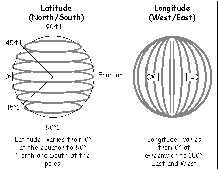
As a pilot, you will be required to either plot a latitude and longitude on a map or to find the latitude and longitude of a specific location.
To Determine the Latitude of a Location
Refer to Figure 1 (below).
- Place your ruler east-west through the location on the map/chart. Make sure that it is parallel to the parallels of Latitude on the rectangular grid bounding the location.
- From the Latitude scales running north-south (marked as ticks on the lines of longitude running north-south) read off the exact latitude. There should be an equal number of ticks/marks above or below the ruler on both the east and the west side.
- The distance between each tick is one minute of arc = 1 nautical mile.
- There are 60 seconds in 1 minute but these are too small to be marked on the map so you will have to judge the approximate amount of minutes. I.e. half way between the ticks is 30 seconds.
Remember that the numbers increase in value as you count from south to north in the northern hemisphere. The reverse would be true if you were plotting for positions in the southern hemisphere.
To Determine the Longitude of a Location
Refer to Figure 1 (below).
- Place your ruler north-south through the location on the map/chart. Make sure that it is parallel to the closest meridians of longitude.
- The Longitude scales are identified by marks on the lines of latitude running east-west.
- From the Longitude scales, read off the exact Longitude. There should be an equal number of ticks/marks east or west of the ruler on both the north and the south side.
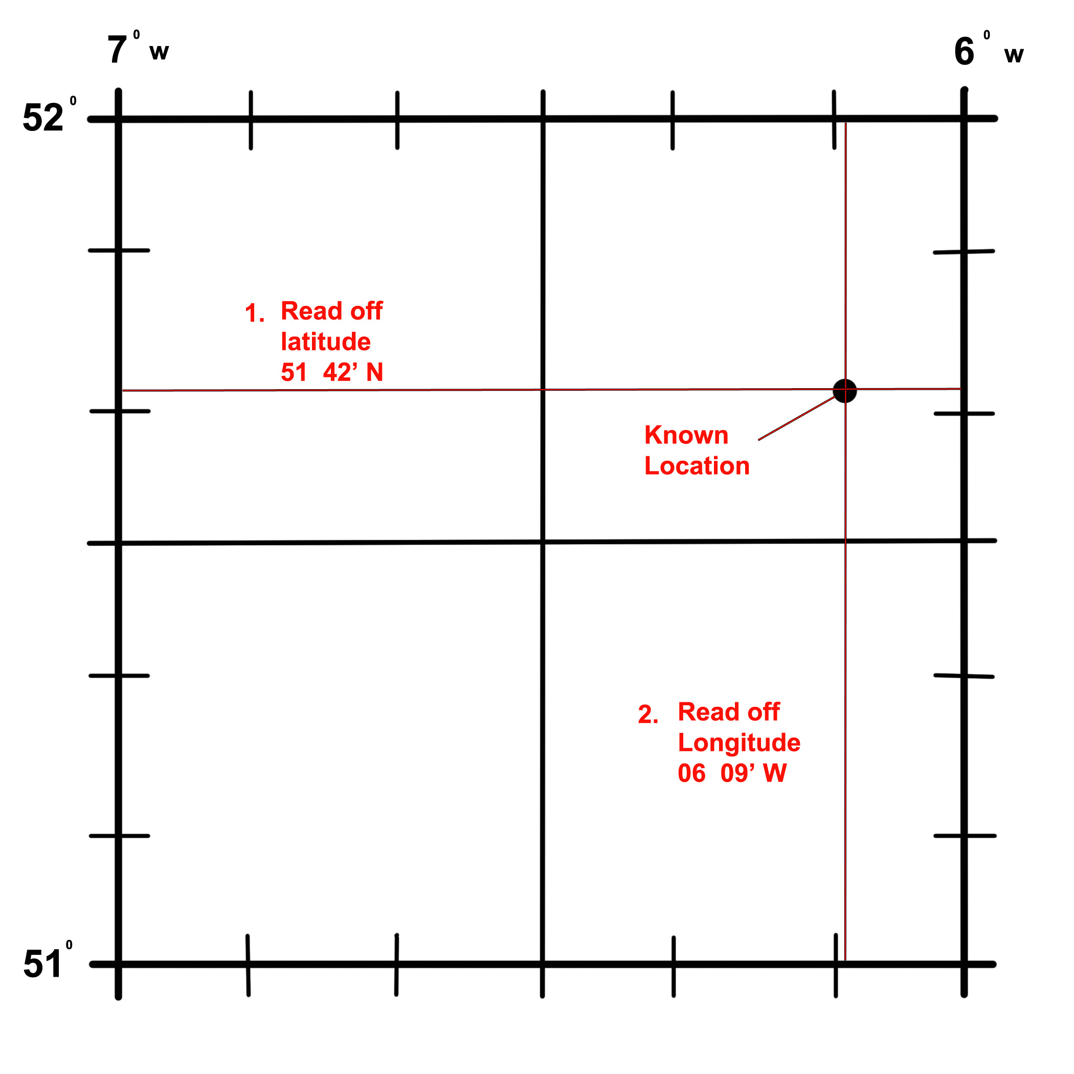
Figure 1
Co-ordinate Notation
Co-ordinates are normally written showing the degrees, minutes and seconds followed by a letter to signify North, South, East or West. As a student pilot, this is the notation you will become most familiar with.
Example:
- 007º 38′ 22″ W
- 52º 49′ 51″ N
But this is not the only notation. Co-ordinates can also be represented using a decimal system. This converts the minutes and seconds to decimal bearing in mind that there are 60 seconds in a minute and 60 minutes in a degree.
Example:
- 7.6394º W
- 52.8308º N
There is one more method that pilots commonly use to represent co-ordinates. This method is called the World Geodetic System (WGS).
Because the Earth is not an exact sphere, the WGS system uses a model of spheroid instead of a sphere and the corresponding locations are imposed unto it. It is more accurate than some systems but it is still not perfect.
WGS84 is the most up to date version in use today and was implemented in 1984. The most recent revision to WGS84 was made in 2004. WGS84 uses a slightly different reference system to locate any location on Earth and is used by the GPS system. Zero degrees longitude in this system is actually located 102.5m east of the Greenwich Prime Meridian.
NOTE
Many pilots have obtained coordinates of locations from the internet and not checked whether the coordinates used the WGS84 system or not. This can lead to wrong coordinates being entered into a GPS unit and subsequent errors in navigation.
To convert from one coordinate system to another, it is easy to use an online convertor – click here
When using the WGS84 system, coordinates may be written in the following format:
| Value | Description |
|---|---|
| Latitude | Latitude of point. Google Earth uses the WGS84 geodetic datum. Valid formats include: N43°38'19.39" 43°38'19.39"N 43 38 19.39 43.63871944444445 If expressed in decimal form, northern latitudes are positive, southern latitudes are negative. |
| Longitude | Longitude of point. Valid formats include: W116°14'28.86" 116°14'28.86"W -116 14 28.86 -116.2413513485235 If expressed in decimal form, eastern longitudes are positive, western longitudes are negative. |