Measuring Latitude and Longitude
(Updated on 28th January 2021)
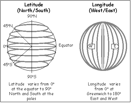
As a pilot, you will be required to either plot a latitude and longitude on a map or to find the latitude and longitude of a specific location.
To Determine the Latitude of a Location
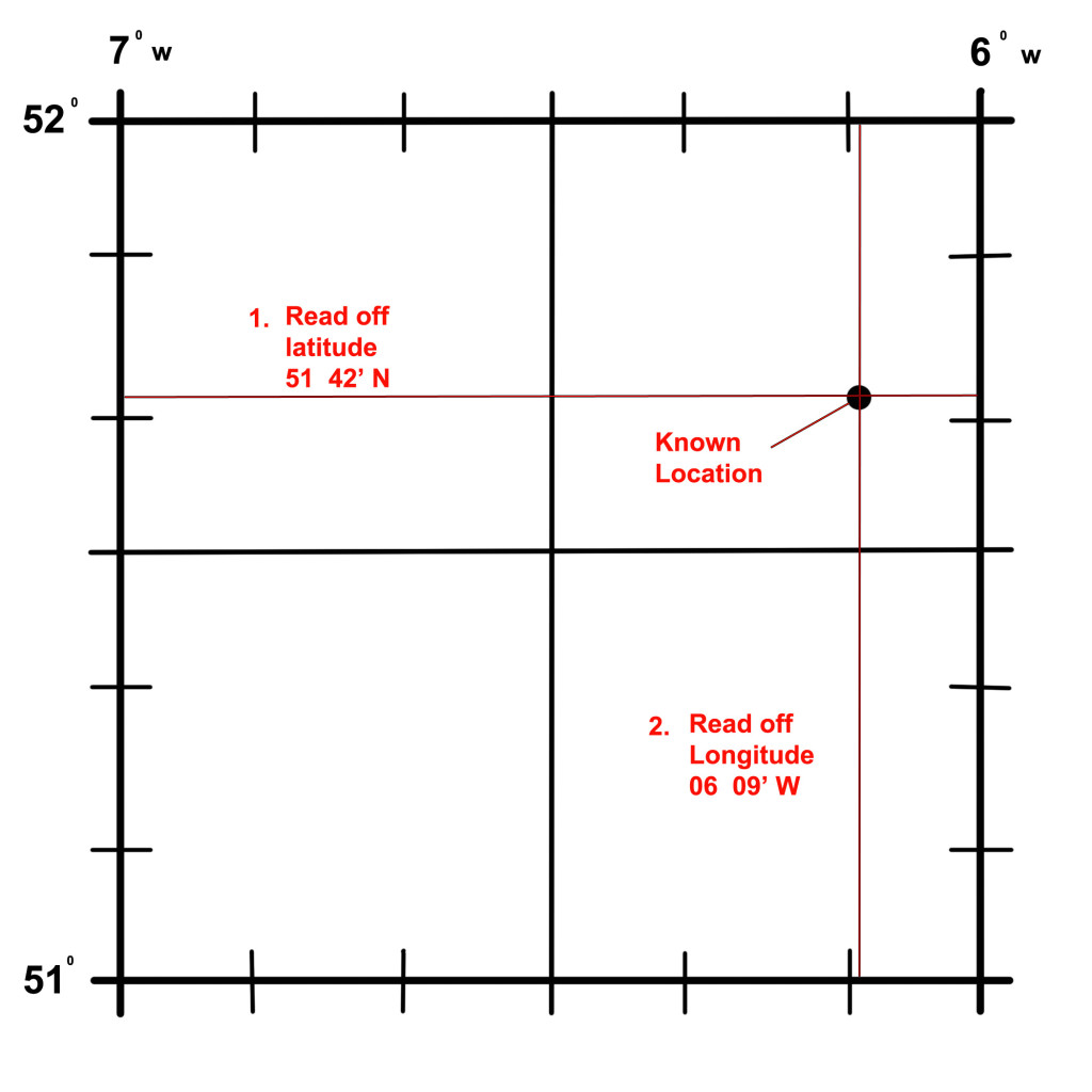
Refer to Figure 1 (below).
- Place your ruler east-west through the location on the map/chart. Make sure that it is parallel to the parallels of Latitude on the rectangular grid bounding the location.
- From the Latitude scales running north-south (marked as ticks on the lines of longitude running north-south) read off the exact latitude. There should be an equal number of ticks/marks above or below the ruler on both the east and the west side.
- The distance between each tick is one minute of arc = 1 nautical mile.
- There are 60 seconds in 1 minute but these are too small to be marked on the map so you will have to judge the approximate amount of minutes. I.e. half way between the ticks is 30 seconds.
Remember that the numbers increase in value as you count from south to north in the northern hemisphere. The reverse would be true if you were plotting for positions in the southern hemisphere.
To Determine the Longitude of a Location
Refer to Figure 1 (below).
- Place your ruler north-south through the location on the map/chart. Make sure that it is parallel to the closest meridians of longitude.
- The Longitude scales are identified by marks on the lines of latitude running east-west.
- From the Longitude scales, read off the exact Longitude. There should be an equal number of ticks/marks east or west of the ruler on both the north and the south side.
Co-ordinate Notation
Co-ordinates are normally written showing the degrees, minutes and seconds followed by a letter to signify North, South, East or West. As a student pilot, this is the notation you will become most familiar with.
Example:
- 007º 38′ 22″ W
- 52º 49′ 51″ N
But this is not the only notation. Co-ordinates can also be represented using a decimal system. This converts the minutes and seconds to decimal bearing in mind that there are 60 seconds in a minute and 60 minutes in a degree.
Example:
- 7.6394º W
- 52.8308º N
There is one more method that pilots commonly use to represent co-ordinates. This method is called the World Geodetic System (WGS).
Because the Earth is not an exact sphere, the WGS system uses a model of spheroid instead of a sphere and the corresponding locations are imposed unto it. It is more accurate than some systems but it is still not perfect.
WGS84 is the most up to date version in use today and was implemented in 1984. The most recent revision to WGS84 was made in 2004. WGS84 uses a slightly different reference system to locate any location on Earth and is used by the GPS system. Zero degrees longitude in this system is actually located 102.5m east of the Greenwich Prime Meridian.
NOTE
Many pilots have obtained coordinates of locations from the internet and not checked whether the coordinates used the WGS84 system or not. This can lead to wrong coordinates being entered into a GPS unit and subsequent errors in navigation.
To convert from one coordinate system to another, it is easy to use an online convertor – click here
When using the WGS84 system, coordinates may be written in the following format:
| Value | Description |
|---|---|
| Latitude | Latitude of point. Google Earth uses the WGS84 geodetic datum. Valid formats include: N43°38'19.39" 43°38'19.39"N 43 38 19.39 43.63871944444445 If expressed in decimal form, northern latitudes are positive, southern latitudes are negative. |
| Longitude | Longitude of point. Valid formats include: W116°14'28.86" 116°14'28.86"W -116 14 28.86 -116.2413513485235 If expressed in decimal form, eastern longitudes are positive, western longitudes are negative. |
Did you enjoy this post? Why not leave a comment below and continue the conversation, or subscribe to my feed and get articles like this delivered automatically to your feed reader.


Comments
No comments yet.
Sorry, the comment form is closed at this time.