Frontology – Weather Charts for Pilots
(Reviewed on 6th February 2021)
Introduction
Just today, one of my students asked me to post some information about fronts. Meteorology is such a large subject, it is sometimes difficult to know where to begin learning. For this post, I am going to concentrate on “Frontology” – the study of weather fronts.
As helicopter pilots, we are very aware of what an important role weather plays on the safety and comfort of our flights. It is important that we can interpret weather charts and decipher coded Meteorological Reports (METARs) and Terminal Area Forecasts (TAFs).
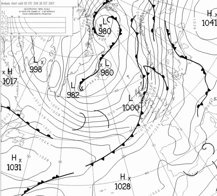
Synoptic charts (pressure charts) are one of the most commonly used charts that we use to try and predict the weather. We are going to look at the fronts on these charts in detail.
The Cold Front 
The best way to think of a cold front is to think of it as a parcel of cold, dense air moving along the surface of the earth. As it moves, it undercuts the less dense, warmer air ahead of it and this causes the warmer air to rise. As the air rises, it creates lower pressure and if there is enough moisture in the air, Cumulus (Cu) clouds will form. This type of cloud can produce showery rain but there will be good visibility in between the showers. Cold fronts can move up to two times faster than a warm front and because of this they can produce sharper changes in the weather.
As the cold front passes, the following occurs:
- A sudden drop in temperature.
- Atmospheric pressure starts to increase.
- The wind becomes gusty.
- Thunderstorms (with sufficient moisture).
- Cumulonimbus clouds .
- A drop in dew point temperature.
- Poor visibility starts to improve.
After the cold front passes, the following occurs:
- Temperature drops steadily.
- Atmospheric pressure increases steadily.
- Wind veers (changes direction clockwise in the northern hemisphere).
- Rain showers start to clear.
- Good visibility
- Falling dew point.
If there is not enough moisture in the air, a cold front may pass without any visible signs as there will not be enough moisture to form clouds.
The Warm Front 
Think of a warm front as a parcel of warm air moving across the surface of the earth. It will have colder, more dense air ahead of it. The warm air is forced over the top of the colder, denser air. This happens at a shallow angle. As a warm front approaches, clouds associated with the front may be seen up to 500km before the front arrives. The first clouds to be seen are the high altitude clouds (Cirrus and Cirrostratus) This is followed by the middle altitude clouds (Altostratus). Close to the front there will be Nimbostratus clouds which produce continuous rain (or snow). When the front passes there is normally a layer of Stratocumulus clouds. As the warm front passes, the following occurs:
- Sudden temperature rise.
- Atmospheric pressure levels off.
- Variable winds.
- Nimbostratus clouds with stratus and sometimes cumulonimbus clouds
- Continuous rain, snow or drizzle stops as the front passes.
- Visibility is poor but improving.
- Dew point rises steadily.
After the warm front passes, the following occurs:
- Temperature rises and then levels off.
- There is a slight rise in atmospheric pressure then a decrease.
- The wind veers (in the northern hemisphere).
- Usually no precipitation but sometimes light rain or showers.
- Clouds clearing to scattered stratus.
- Visibility is fair in haze.
- Dew point rises and then remains steady.
The Occluded Front 
An occluded front is formed when the faster moving cold front overtakes the warm front ahead of it. There are two types of occluded front.
- Cold Occluded Front. This occurs when the air behind the front is colder than the air ahead of the front.
- Warm Occluded front.This occurs when the air behind the front is warmer than the air ahead of the front.
A wide variety of weather may be found along an occluded front. They usually form around mature low pressure systems.
Synoptic Charts
Now that you know what the different types of front are, you are capable of making better decisions during your flights or during your flight planning. You can make reasonable predictions about the kind of weather you are likely to encounter. There are other symbols on the charts and lots more information can be derived. I will cover this in another post. One of the Meteorological websites I commonly use to get this information is Propilots.
Did you enjoy this post? Why not leave a comment below and continue the conversation, or subscribe to my feed and get articles like this delivered automatically to your feed reader.


Comments
No comments yet.
Leave a comment